Wednesday, May 22, 2013

Relatives, The Pocomoke River and the Great Dismal Swamp

Tuesday,  May 14, Day 22

We are headed to Norfolk and Newport News today, to see more of the Avery family.  

We did things a little backward, stopping at the visitors center on our way OUT of Manteo, but we wanted to pick up some additional literature.  Right at the visitors center was this cemetery, and a plaque.


This was a reminder to me that during the Civil War, escaped slaves came to Roanoke Island in droves, seeking asylum.   LIncoln had not yet issued the Emancipation Proclamation, and so the Union officers came up with the idea of calling them "contraband".  The slaves were considered property in the South, so the North said they were seized property.  Here on Roanoke Island, they built communities, went to school and church and learned trades that would be helpful after the war.  However, after the war, the United States turned the island back over to its original owners and most of the AfricanAmericans were once again forced to leave the area.  Many of them did stay, however, and there is a portion of the Manteo community dedicated to them.  


We are only a short way from  Norfolk, where we will meet Stanley and LeeAnn Avery, and Ann Bunn Avery.  These are Blake relatives that we have not met before.   We also planned to meet Karen, whose husband Erwin recently passed away, but she was not able to get off work.  

 Lee Ann Avery

 Ann Bunn Avery


John with Stanley and Waitstill his son, who dropped by unexpectedly.


A lovely luncheon was prepared and we had a chance to talk while we ate.  This meal was so reminiscent of ones we had many times at John's grandparents on Long Island, New York.  It was really nostalgic for me.


 It was delicious.


Lee Ann had to scoot off to an appointment and Ann Bunn wanted to get back home to Newport News before the traffic got bad, so our visit was short, but wonderful.

Before leaving, they shared with me this photo of LeeAnn and Stanley's grandchildren.  Twenty-seven family members rent a big house on the Outer Banks during the summer.  John always wanted to know who rented those big houses, and now we know.  What fun they must have!   It was great to meet the cousins we had been writing to for 50 years and had never seen!  


Little did we know that we were about to encounter our own bridge crossing, the Chesapeake Bay Bridge Tunnel.  It is close to 20 miles long,  and is the main north-south highway to Virginia's eastern shore.  It has two mile long tunnels, low level trestles, a high level bridge, two man made islands.


We were actually going under the ship you see coming over the highway!


We wanted to head out to Chicoteaque Island to camp, but Virginia doesn't tell you that it is only a wildlife refuge and you can't stay there.  It is over an hour and a half to the Maryland side and camping, so we look instead for an alternative.


You have to get practically to Ocean city Maryland before you can cut down to the park. 

We found the Pocomoke River State Park as an alternative campsite.  

This is part of a 65 mile Pocomoke River, the eastern most river that empties into the Chesapeake Bay.  
It is also part of the Great Diksmal Swamp, which is actually in Delaware.  Who knew?  It is the northernmost stand of cedars.  You can see the coloration of the water.


It is also supposed to be one of the deepest rivers in the world for its width.  Lots of distinctions!

Joe Biden wanted to make this a National Park, but the locals objected, feeling it would attract too many tourists!


John takes time to go onto the roof and clean off the slide-out since we have lost the protective cover for the time being.

We had a wonderful relaxed evening and morning here.  And tomorrow we will head to Assateaque, this time on the Maryland side!


The Wright Brothers Memorial

On our way back from Currituck, we stopped at the Wright Brothers National Memorial in Kill Devil Hills. 


This painting of the two of them adorns the wall of the visitors center.


This picture taken of the first moment of flight is so iconic.  The guy who was set up to take the picture got so excited he didn't remember if he had snapped the photo.  Turns out he had!


 The selection of the location for the flight, along with the tremendous amount of time the two brothers had spent in learning about and determining what would make a man made object fly... pitch, roll and yaw,  was pretty impressive.  Here I always thought it was trial and error.  Which it was, but with a lot of research and understanding of what they were doing.


 Most of the time, you think of great inventions as being by a lone scientist somewhere.  The fact that these two brothers worked so well together was a tribute to their dedication.  And, it turns out they got their drive from their mother, whose family was in the carriage making business, and she understood  about mechanics.  When she died, it was their sister who encouraged them to keep going.  Their father was a minister and not so mechanically inclined.  Go, girls!


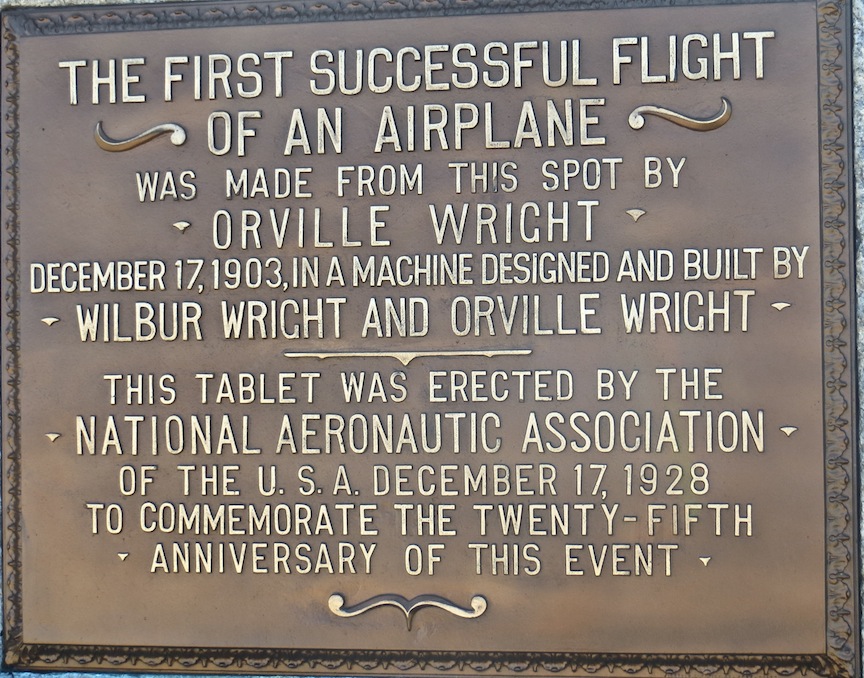
This plaque is near where the flights actually took place.  And up on the hill is the monument, erected in 1928.   Talk about shifting sands, the hill had moved 460 feet since the time they took their flight to the time the monument was built.  It took a lot of work to stabilize the hill first.


Orvillle and Wilbur took turns trying to fly, and it was Orville's turn when they made the 59 second flight that they determined was under control and not just luck.

The stones depict the length of the flights they took the day they were finally successful.

This is a beautifully constructed monument, with wings on the sides.  It is just hard to imagine what came so quickly after this flight.  They obviously understood what they had done and were able to build from there.

North to Currituck and the Wild Horses

Monday, May 13, Day 21

Today we are off to explore the north end of the Outer Banks.  Along here at first, we see a lot of older structures.  

The roadside is being built up with sand along here, although Cedric says the dumping of sand has caused greater erosion in many areas.  People are willing to put up with hurricanes, flooding, loss of homes and belongings, etc., which is really dedication to this area.


The north islands are almost solid homes all along the road, whereas the south road we took yesterday is sparsely populated in comparison.


We arrived at the Currituck lighthouse.  This one isn't painted and I realized that all the rest we have been are made of brick as well.  However, they have the different paint and stripes to be identifiable at sea.  Currituck was built in 1875, and provided the last link among the lighthouses on the Outer Banks.   This area has a little village, lots of shops, and places to explore.


John takes a seat at the light keepers renovated house, which is now a gift shop.  Guess where Cedric and I are!

They had a little food shop outside, where we got some barbeque sandwiches  The pulled pork here is flavored with vinegar, so it has a different flavor than the sweet sauces of other parts of the South.  But,  this really good! 


Cedric and I opted for a walk along a boardwalk built over a wetlands. 


We spotted this little nutria munching away.  Looks cute, but these big members of the rat family have really taken over a lot of areas.  Or are they related to the beaver?  I forget... but still cute!


We went to a bookshop and I couldn't resist this picture of a David Sedaris book display outside.  The same book Chris and Kayla had sent me the day before on my Kindle.


We headed past the lighthouse out to the end of the island where the Wild Horses are supposed to be.  However, you have to drive out on the beach to get to where they are.  These horses have been verified to be Spanish mustangs from shipwrecks.  They live on 7500 acres and are supported by a nonprofit called The Corolla Wild Horse Fund.   You can take a tour out here, but we weren't prepared to do that,  and we don't have four wheel drive, so we have to be content to read about them and look at the birds along this fence that keeps the horses on their end of the island.


As we head back south, Cedric takes us on a little detour to see a lone house, the one left standing, after all the others along here have fallen into the ocean.


I didn't notice until I loaded this picture, but it is obvious that grasses have been planted along here to try to stop further erosion. Hope it works!

Romance at the Cape Hatteras Light Station

Sunday May 12 cont'd

We had continued on down the Outer Banks to Ocracoke, where you have to take a 40 minute ferry ride to the next Island. So we're going to turn around there.  The dunes have been built up along the road, so you can't see the water. Sand is drifting over the road, and there are inlets cut through the island to the sound, traversed by temporary bridges until the sand fills back in.  You quickly realize how constantly the landscape changes along here.  

 Ocracoke was where Blackbeard met his fate.  And it is the home of the museum, Graveyard of the Atlantic, which documents some of the 600 shipwrecks that have occured along here.  There are tributes to the life saving stations, where men in row boats pulled shipwrecked sailors and passengers from the wreckage and waves.  These life saving stations are the stuff of many a folklore along here.   But we were about to make our own folklore!

We stopped at the Cape Hatteras Light Souse on our way back north.  Built in 1870, it is one of the landmarks along this coast.  Cedric had stopped at this sign and asked a young couple if she could take a picture of them, to which they eagerly agreed.   

As we came to the lighthouse,  Cedric took our picture.  And then along came another couple, strolling hand in hand.  Cedric did what she always does -- offered to take their picture.  

Suddenly, the man says, "Now is as good a time as any," and he reaches in his pocket for a ring box, gets down on his knee and proposes!  Cedric is happily snapping away, but my camera is in her pocket and I didn't get a picture of the actual moment !


However, with my zoom lens, I did get a picture of the ring, after I grabbed my camera out of Cedric's jeans pocket.  This was a little hard, because Cedric was down on her knees, snapping pictures like crazy on the guy's camera!


 The girl was so surprised.  They had been to a wedding the night before where he had been the Best Man.  He had tried to get her to come out here and go up in the lighthouse with him earlier in the day, but she had been reluctant to climb those narrow stairs.  So, they had just come out to look before going to dinner.  But, having a camera person suddenly available, he decided to propose right then.


 The bride- to- be was so happy and crying.  She was surprised and had never seen the ring. She had me crying, and hugging them both.  After we wished them lifelong happiness, we left them to their privacy as they enjoyed the moment -- and with pictures they never expected to have.


 We went on down the coast and explored an area where the lighthouse had previously stood, until erosion forced its removal and relocation. The story of how they moved it is interesting in itself!


 This stone marks the spot of a burial near the old lighthouse in 1896.


We went home reveling in a beautiful sunset, a surprise engagement and all in all a wonderful day! Both of my sons had called me for Mother's Day and given me such thoughtful gifts.  I am so lucky!

The Outer Banks -- The Atlantic Ocean at Last!

Sunday, May 12, Day 20 and Mother's Day

The outer banks are a series of barrier island that run about 150 miles along the North Carolina and Virginia coasts.  It's a lot bigger than I thought.  It includes towns we all know - Nags Head, Cape Hatteras, Kitty Hawk, Kill Devil Hill.  


And here's our friend Cedric.  It's so good to see her!  We lost GPS on our phone and had a little trouble finding her house, so we were a little later than we thought we would be.   We have parked our camper in her yard and are ready to explore! 


The first place she takes us is Fort Raleigh.  It is here that the first explorations and attempts were made to establish a presence in the Americas in 1584.  They were spearheaded by Sir Walter Raleigh, who had become a "confidant" (and much more) to Queen Elizabeth.  Ironically, Raleigh never came here.  
I was amazed at the thought and deliberations that went into this exploration.   England was worried about the vast presence that Spain had developed in the lower Americas and they determined to 
stop the nothward migration of Spanish settlements.  And, although we are taught in school that the first Europeans came for religious freedom, in fact, they were after riches of gold and silver, just like the Spaniards.  They also wanted a place where they could raid the vastly rich Spanish galleons that were taking their plunder back to England and using the Gulf Stream currents to get them across the Atlantic.  They had to pass right by here like sitting ducks! 

The first group of 600 tried to make it, but they tired of waiting for supplies, had lost a lot of people and decided to return to England with Sir Frances Drake, who had been pirating along the coast.  

The first two trips were for exploration.  They had artists and metallurgists along to test whatever minerals they could find.  They even built earthworks and established laboratories. And here I thought it was just poor people looking for a better opportunity. 


On the second voyage, 15 men had been left to maintain a foothold for England in the new colony.  By the  arrival of the third voyage, they were all gone, most killed by Indians whom they had managed to alienate both through the introduction of disease , misunderstandings and subsequent killings.  They had relied on trade with the Indians for food, and when the Indians stopped trading, things deteriorated quickly.  Only  one skeleton was found when the third voyage came, the rest  of the men had just disappeared. Foreboding of things to come! 

It is the 1587 trip that we are familiar with.  The one that brought families, (i.e. women and children)  along to establish a colony.  Two of the women were pregnant and gave birth within a few weeks of one another.  But the first born was Virginia Dare.  Her parents, Elenor  and Ananias Dare, were the  daughter and son-in-law of John White, an artist who had painted portraits of the indians and also the flora and fauna of the area on earlier voyages. 


John White had gone back to England to raise more money and get provisions to bring back to the fledgling colony.  Unfortunately, he arrived in England just as hostilities were heating up with Spain, resulting in the Spanish Armada  and its defeat at the hands of Sir Walter Raleigh.   The Queen and  Raleigh were preoccupied and didn't have time to think about John White's family and the others they had left in Virginia.  They had lost interest.  When he finally got back to Roanoke three years later, everyone was gone.


They had made a prearranged agreement that the colonists would carve letters into a tree telling where they had gone.  This is what they left, "CRO." And the word "Croatoan" carved into a post. White, thinking that they had gone south to the Croatoan Indians  made an attempt to go there.  A hurricane forced the ships to return to England, and they never did find out what happened to the colonists.  Can you imagine the emotions of John White, who left his daughter and her husband and his new granddaughter to a fate unknown? 


There is a  outdoor play about the Lost Colony that has run for many years.  It is in this amphitheater.  It will start the end of May and run every night through August.  It is packed for each performance.  We are a little early for this, but we enjoyed watching the actors and students come in to prepare for the staging.  


 We went to downtown Manteo and had a wonderful oceanside view at the Waterside Grill, where we enjoyed fish tacos and sea trout sandwiches.   Oh and some wine  It's Mother's Day, you know.


After a brief stop at home, to get warmer clothes on, we headed south on the outer banks.  The houses are all built on stilts, lots of new construction, and they all take on pretty much the same style.


And at last, we see the REAL Atlantic Ocean.  Up until now, we have been on the four inner sounds of the outer banks, but this is the wide open ocean!  This is our 3,830 mile mark! 


John strikes his familiar pose.  "It doesn't get any better than this."


And here we are!  Coast to coast....


I'm a little apprehensive of that rogue wave that may come in while my back is turned!  But one must dip their toes in the Ocean, right?


This is a great area to collect shells, and who can resist that? 


It's late in the day, so Cedric and I have some fun with our shadows!


Cedric is finding that one shell that is better than the rest.


Time to move on.  There is so much history along here, as evidenced by this famous event with the Monitor and Merrimac.

Big in WWI here as well, as the Germans took out a lot of our cargo ships along this coast with their submarines.